After a general review of the AstroQueyras observatory context, here are some of my notes related to the observed weather and night sky quality during my stay. On the first two nights (August 29/30 and 30/31) the sky was clear but seeing was quite mediocre. I have note a particular phenomenon that I hardly explain: a persistent south-east wind.
On global conditions
When analysing a given meteo situation (to make a night weather forecast for example), I first take a look at three charts in particular: ground pressure, ground wind, and jetstream. Ground pressure gives a first idea about conditions (anticyclonic or not). Ground winds on my usual lowland site looks to determine strongly the seeing, and the jetstream, for the same reason, whose direction and strength do influence the seeing.
Here is the situation on the night of August 29th to 30th 2015 (the following night was comparable):
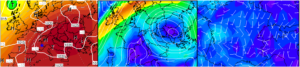
At left is the ground pressure chart (the blue star indicates the position of Observatory), in the middle is the jetstream, and at right is the ground wind. This data draws a situation strongly anticyclonic, with faint jetstream and ground wind ; this being in first place very favourable to a good seeing. But this was not the case!
An unexplained night time wind
Weather at sunset was fine, with no wind and warm temperatures. But once the night had fallen, a persistant 30 km/h wind began to blow from the south-east. besides being unpleasant, it was blowing directly inside the domes, making strong air turbulences.
Meteo charts don’t explain that wind. It was blowing in a continuous way, with no real gusts or lulls. This feeling reminded me of an unsually warm night of 2011 October very close to the sea. Ground wind according to charts was supposed to come from the sea (at south) to bring excellent seeing. But this was an unpleasant and persistant ground wind that was blowing (from the north). This was due to a local wind cell invisible on charts, the sea being noticeably warmer than the ground, the cool air above this last one was substituting itself to the warm sea air. Seeing at night was atrocious!
My hypotesis is that that night time wind at AstroQueyras was due to an equivalent situation. The weather over the last days had been unusually warm due to hot air masses coming from the Maghreb, bringing ground temperatures much higher than 20°C during the day, which is quite rare at an altitude of 3000 m! West of the observatory, the adret is facing the afternoon Sun and I think it gathered heat during hours, a heat returned to the atmosphere at night. And this was generating the south-east wind from opposite direction.
Sinking clouds in the depth of valley…
During those two days I noted a particular phenomenon, that ceased thereafter. Whether it was a mere coincidence or truly correlated, convective clouds that form almost every day above the italian slope beyond the depth of the valley were “sinking” into the valley above the pass. The image below (taken on August 29th at 17h30 UT) shows the situation.
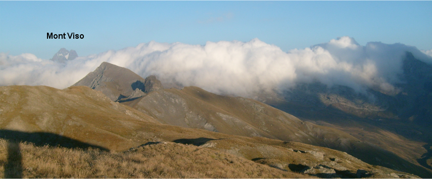
I have no explanation for this, but it ceased with the global change of weather condition during the 31th of August.
Dissipation of wind during the second night
During the second night I was at command of the new T500 to test it for Uranus imaging. From 1h30 (local), this strange wind progressively stopped, and the seeing improved in the meantime (however it was still not very good). Temperatures plummeted during the last hours and it even briefly frosted at sunrise. Had the ground around the observatory terminated to evacuate its heat?
To be followed: good seeing is coming!
: the onset of good conditions")
